The
Venezuelan Plains (Llanos) are located in the country central
depression, having the Andes and the Coastal Mountain Range by
one side and the Guayana Massif by the other. This wide region
extends from the Andes foothills to the Atlantic Ocean through
the lowlands of the Orinoco Delta, covering about one third of
the Venezuelan territory.
Due
to geomorphologic reasons, Venezuelan Llanos are subdivided into
four regions: the Eastern Llanos of Anzoátegui and Monagas
states (39,900 sq. Kms.) with a predominating relief of mesas;
the Central Llanos of Guarico and Cojedes (71,400 sq. Kms.) with
their rises and hills: the Western Llanos of Portuguesa and
Barinas (51,200 sq. Kms.) with a flat topography and
more-or-less channeled rivers; and the southern Llanos of Apure
( 74,500 sq. Kms.) mainly characterized by floods occurring
during the rainy season and where rivers and bayous show
wandering courses.
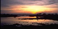
As
far as climate is concerned, even though temperatures are high
and relatively constant all year long, by contrast, rainfall is
remarkably seasonal. There is a rainy period from May to October
during which floods occurs, transforming the savanna into a true
sea, to the point that very often cattle have to look for food
literally ¨ in deep water ¨.
There
is also a dry season, from December to March, during which one
can say that not even a raindrop falls. April is considered to
be the beginning of the rainy season since it is usually during
this month that the first rain falls.
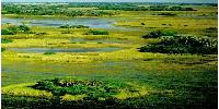
Venezuelan
Llanos show a totally different look depending on the period of
the year. It is possible that a tourist who visits Apure in ¨winter¨
will not be able to recognize the same area in ¨summer¨: he
will deem impossible that such luxuriant greens and blues may
become pale yellow and earth - colored.
Location:
Center, southwest and southeast of Venezuela.
States:
Guarico, Apure and Barinas.
Apure
State: Area: 76.500 sq. Kms.
Capital:
San Fernando (Official government census 1.990: 72.216 ih.).
Population:
285.412 ih. (Official government census 1.990).
Relief:
Alluvial plains. Seasonal floods during the rainy season.
Hydrography:
Dense fluvial net, the rivers: Apure, Orinoco, Apurito,
Arauca,
Capanaparo, Meta, Cinaruco y Sanare, permitting fluvial
port,navigable and fishing activities.
Climate:
Hot .Marked seasonal. Temperature average 27º C. Rainy annual
average 1.533 mm.
Vegetation:
Typical of tropical savannas with pluviometric seasonal.
Barinas
State: Area: 35.200 sq. Kms.
Capital:
Barinas (Official government census 1.990: 153.630 ih.).
Population:
424.491 ih. (Official government census 1.990).
Relief:
It is principally plain, at the west of the state to be situated
the
Sierra
Nevada National Park belonging at the Andes Range.
Hydrography:
Belong at the Orinoco wooden bowl. The principal rivers:
Guanare,
Masparro, Santo Domingo, the Anaco, Caparo y Suripá.
Climate:
Hot temperature .Marked seasonal. Temperature averages 27º C.
Rainy
annual average 1.533 mm.
Vegetation:
It is savannas: Higrófila - Tropófila and Tropófilas jungles,
The
more important is the Ticoporo Jungle.
Guárico
State: Area: 64.986 sq. Kms.
Capital:
San Juan de los Morros (Official government census 1.990: 67.791
ih.).
Population:
488.623 ih. (Official government census 1.990).
Relief:
It is principally plain, in the northeast Coastal Range.
Hydrography:
Orinoco river wooden bowl: Tiznados, Guárico and Suata rivers.
Climate:
Warm, the rainy season is from May to October. Temperature
averages 26º C. Rainy annual average between 500 - 1.000 mm.
Vegetation:
It is savanna higrófilas y tropófilas.
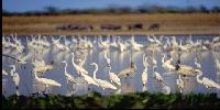
Ecotourism
& Adventure
Highlights:
Aguaro
- Guariquito National Park (Guárico State).
Hato
Terecay (Guárico State).
Mochima
National Park (Anzoátegui State).
Hato
El Frío & Hato San Leonardo (Apure State).
Cinaruco
Bass Lodge & Hato San Leonardo (Apure State).
Ecotourism
& Adventure
Activities:
Natural History Tours. Birdwatching.
Nature Photography Workshops. Photo
Safaris. Sea Kayaking. Caving. Canoeing.
Fishing. Biking Tours. Trekking. Overland
Tours. Scientific Expeditions & Tours.
Cultural Tours. Helicopter Tours. Peacock
Bass Fishing.


 Eco-Portal
Wildlife Venezuela
Eco-Portal
Wildlife Venezuela 